Designing for Flood Levels Above the Minimum Required Elevation: Lessons from Hurricane Ian in Florida
In the wake of Hurricane Ian, which caused extensive flooding in Florida in 2022, a new Recovery Advisory has been drafted with valuable insights for future construction and retrofitting of buildings to enhance flood resilience. These insights are particularly crucial as flood levels during Hurricane Ian far exceeded the base flood elevations (BFEs) mapped on the Flood Insurance Rate Maps (FIRMs) in some areas.
Enrique Lairet, PE
8/8/20238 min read


Introduction
In the wake of Hurricane Ian, which caused extensive flooding in Florida in 2022, a new FEMA Recovery Advisory has been drafted with valuable insights for future construction and retrofitting of buildings to enhance flood resilience. These insights are particularly crucial as flood levels during Hurricane Ian far exceeded the base flood elevations (BFEs) mapped on the Flood Insurance Rate Maps (FIRMs) in some areas.
The guidelines provided in this advisory are applicable not only to Florida but also to buildings with similar vulnerabilities in other regions. They cover aspects of flood insurance studies (FISs), flood mapping, and regulations for elevating buildings beyond minimum required elevations.
Key Concepts
Target Audience
The advisory is aimed at designers, local and emergency management planners, building owners, and operators, as well as stakeholders involved in new construction in hurricane-prone areas.
Building Elevation
The document provides detailed guidance on how to determine the appropriate elevation for a building, with a focus on exceeding the minimum elevation required by the Design Flood Elevation (DFE). The DFE is a regulatory flood elevation adopted by the local community, often aligned with the BFE plus any additional freeboard. The advisory emphasizes designing above the DFE to minimize flood damage, as depicted in Figure 1 (above) with three buildings showing varying elevations and damages after Hurricane Ian.
Terminology Explained
The advisory introduces essential terms related to flood mapping and construction regulations, including:
Flood Insurance Rate Map (FIRM): The official map delineating flood hazards and risk premium zones.
Flood Insurance Study (FIS): A detailed study of flood risk data for specific areas.
Special Flood Hazard Area (SFHA): An area with specific flood hazards.
Base Flood Elevation (BFE): An elevation representing a flood with a 1% annual chance.
Stillwater Elevation & Depth: Definitions related to the surface and depth of floodwater, excluding wave effects.
Understanding Flooding
Flooding can inflict sudden and diverse types of damage, depending on the nature and extent of the floodwaters. This section delves into the specific effects of flooding when levels exceed the lowest floor elevation of a building, with insights from Hurricane Ian in Florida. Understanding these damages is essential for future construction and flood mitigation planning.


Types of Flood Damage
Inundation Flooding
In Zone A areas, where inundation flooding (low velocity, without waves) occurs, buildings may be submerged, and contents wetted, but often without extensive structural harm. However, if water doesn’t equalize inside and outside the structure, hydrostatic loads can potentially cause structural damage. Wet floodproofing techniques can help in equalizing these loads (see NFIP Technical Bulletin 7, Wet Floodproofing Requirements and Limitations).
Severe Flooding with Waves
In areas like Zone V and Coastal A Zone, where waves and high velocities accompany flooding, the effects can be more catastrophic. This is due to the "wave slam," a phenomenon where large structural loads are imparted on buildings by breaking waves. For example, for a residential structure with a 5-foot stillwater depth, a wave crest extending above the floor joist by 1 foot exerts 312 pounds per foot (lb/ft), increasing significantly with higher waves. Wave slam loads can be calculated using equation 8.7 in FEMA P-55, Coastal Construction Manual.
Probability of Exceeding Flood Levels
Flood Insurance Rate Maps (FIRMs) depict regulatory limits and elevations for a 1% annual-chance (100-year) flood event. Building merely to these elevations safeguards only against the base flood, but some storms, like Hurricane Ian, result in flood levels exceeding the BFE.
The figure below illustrates the probability of a flood exceeding various flood levels during given time periods. For instance, there is an 18% chance that the 100-year flood level will be exceeded in a 20-year period, and a 51% chance in a 70-year period.
Required Design Considerations
3.1 Elevation Requirements
To comply with the National Flood Insurance Program (NFIP), newly constructed buildings and those undergoing substantial damage or improvement must meet the Base Flood Elevation (BFE). This can include adding a safety factor known as freeboard, resulting in a Design Flood Elevation (DFE). Some communities require elevation above the BFE to mitigate flood risks further. Building owners and designers should consult with officials to understand these minimum elevation requirements.
3.2 NFIP Requirements and Mapping Guidance
Federal Emergency Management Agency (FEMA) provides Flood Insurance Rate Maps (FIRMs) to reflect flood conditions and delineate Special Flood Hazard Areas (SFHAs). These maps are essential for regulating floodplain development. However, limitations exist, and recently, floods like Sandy (2012), Michael (2018), and Ian (2022) have exceeded the BFEs in several areas. Comprehensive guides on coastal FIRMs are available in various FEMA publications.
3.3 Building Codes and Floodplain Management Regulations
Building codes like International Building Code (IBC) and ASCE 24 standard for Flood Resistant Design and Construction provide freeboard requirements. Florida, for example, has adopted 1 foot of freeboard, and the Coastal Construction Control Line (CCCL) program provides specific guidelines for coastal areas. Further information on building codes in Florida is available here.
3.4 Building Height Restrictions
Height restrictions may limit the amount of freeboard that owners desire. It's crucial for designers to work with communities to achieve improved flood damage resilience, understanding any zoning or building regulation that might apply.
3.5 Importance of the Building to the Community
Certain essential community structures like police stations, hospitals, and emergency centers require higher elevation standards for continued functionality during severe floods. This extends to buildings posing a high risk to the public if damaged by flooding.
3.6 Federal Grant Requirements
Projects utilizing federal funding may have specific elevation requirements according to the Federal Flood Risk Management Standard (FFRMS). These specifications should be checked in the respective funding opportunity notifications.
How High Should a Building Be Elevated? Key Considerations
Selecting the appropriate elevation for buildings is paramount to mitigating flood risks. The minimum required elevation often dictated by state or community mandates may not always suffice. Here, we explore the key aspects to consider, as per FEMA's recommendations, when determining the suitable elevation for a building.
1. Age of the Effective Flood Analysis
Understanding the age of the Flood Insurance Studies (FISs) and Flood Insurance Rate Maps (FIRMs) is crucial, as older data may not represent the current risk landscape. Changes in topography and development could understate the actual flood risk. FEMA suggests elevating buildings above the Base Flood Elevation (BFE)..
2. Availability of Preliminary FIRMs
Utilizing "Preliminary" FIRMs, which are issued prior to the final FIRMs, can offer the latest insights into flood risks. If preliminary BFEs are higher than effective ones, it's wise to use them as a design basis.
3. Building Owner and Operator Tolerance for Damage
The experience of disruption and damage, as witnessed during events like Hurricane Ian, leads to a need for understanding risk tolerance. Measures such as higher design elevations and robust flood-resistant construction practices play a role in reducing similar disruptions in the future.
4. Essential Facilities
Elevating essential facilities such as schools and utilities to a minimum of the code-mandated elevation, community-mandated elevation, or 500-year flood elevation is recommended.
5. Future Conditions
Future environmental changes, including sea level rise and increased storm intensity, must be considered when deciding building elevation. Planning for these conditions enhances the resilience of buildings over their life span.
6. Residual Risk
Residual risk, defined by the U.S. Army Corps of Engineers, refers to the remaining flood risk post-implementation of flood damage reduction measures. Understanding this concept is vital for assessing risk tolerance and selecting an appropriate freeboard amount.


Coastal Erosion
Types of Coastal Erosion
Coastal erosion can be divided into two primary categories: erosion linked to shoreline retreat (due to sea level rise, etc.) and storm-induced erosion. The latter poses significant risk to structures during flood events.
Effects of Erosion
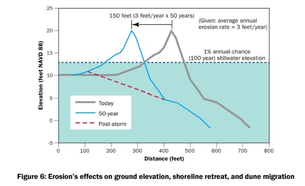
Erosion affects ground elevations, leading to increased flood depths. Its effects are complex, encompassing both general erosion over large areas and localized scour, particularly around objects like foundation elements (Figure 6).
Estimating Shoreline Retreat Erosion
Various processes contribute to shoreline retreat, including sea level rise, wave action, and longshore drift. FEMA P-55 outlines methods for predicting coastal erosion, while historical erosion rates can be found at sources like the USGS’s Coastal Change Hazards Portal.
Estimating Storm-Induced Dune Loss
Storm-induced dune loss is critical for structures near dune systems. Procedures for estimating this erosion type are detailed in FEMA P-55, and upcoming guidance is set to provide more details, with an anticipated publication in late 2023.
4.2.3. Increased Wave Height
Understanding wave theories and calculating potential wave heights is vital, particularly when considering factors like sea level rise or selecting higher stillwater elevations. Methods include calculations for breaking wave heights and overland wave heights, with specific guidance for different flood zones.
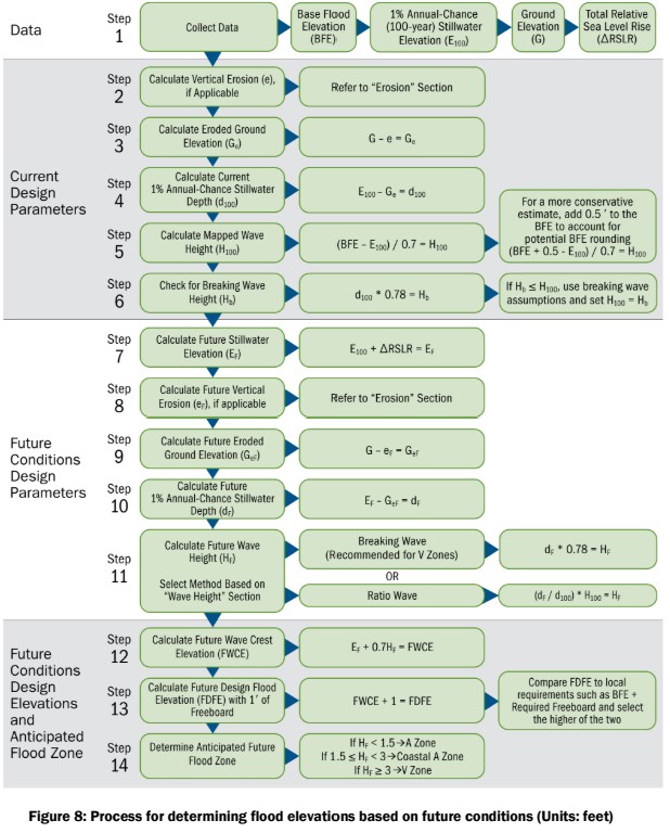
4.2.4. Determining Flood Elevations Based on Future Conditions
This section outlines a 14-step process for calculating future flood conditions (Figure 8). It covers everything from data collection (Base Flood Elevation, stillwater elevation, ground elevation, total relative sea level rise) to defining current and future design parameters and future flood zones.
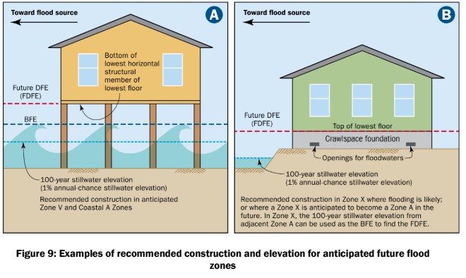
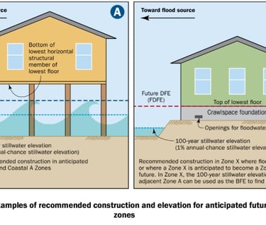
4.2.5. Anticipating Future Flood Zones
For enhanced resilience, considering future flood zones is essential. Constructing buildings that meet future flood zone requirements ensures foundations can withstand future flood conditions. Chapter 10 of FEMA P-55 offers guidance on foundation design in coastal areas.
Additional Design Considerations for Mitigating Flood Damage
When considering flood damage mitigation, a comprehensive approach should be implemented, not only taking into account the direct impact of flood hazards but also associated wind hazards during hurricanes. The detailed guidance can be followed through FEMA's several publications, including FEMA P-804 and FEMA P-499.
5.1. Design Loads
In flood zones, design loads need to be calculated with precision. They include various conditions like hydrostatic, hydrodynamic, wave, and other loads, considering both long-term and storm-induced erosion. Calculations must consider the future stillwater elevation and wave conditions. Though elevating a building results in nominally higher wind pressures, the increased resilience against flood loads offsets this cost. Therefore, every aspect of the building, from foundation to roof and envelope system, must be designed to bear these increased loads.
Find detailed calculations for flood and wind resistance at www.windcalculations.com.
5.2. Use Strong Connections
A building's continuous load path plays a key role in withstanding loads such as wind, seismic, and flood. Every link in this path should be strong enough to transfer loads without failing. In the case of flooding, special consideration is needed for connections between foundations and the elevated building to prevent it from washing away or floating. Anti-corrosion measures and annual inspection and maintenance should also be implemented for these connectors.
For further information on strong connections and corrosion protection, visit www.oasisengineering.net/consulting.
5.3. Use Flood Damage–Resistant Materials
The use of flood damage–resistant materials is paramount below the Base Flood Elevation (BFE) or the lowest floor, including wall construction and floor finishes. These materials must be compliant with the National Flood Insurance Program (NFIP) and should be considered for both new constructions and substantial improvements.
Wet floodproofing might be used as a voluntary retrofit measure, and building owners should consider using drainable, dryable interior wall assemblies and other flood-resistant methods and materials like pressure-treated wood framing, non-paper-faced gypsum wallboard, and water-resistant flooring.
For additional guidance on flood damage-resistant materials, refer to NFIP Technical Bulletin 2 or consult www.oasisengineering.net/consulting.
These additional design considerations ensure that buildings are not only designed to withstand flood hazards but are also resilient to other related dangers like wind-driven rain and debris during hurricanes. By adopting these measures, property owners can significantly minimize potential damage in the event of future flood events.
Conclusion
Elevating buildings in flood-prone areas is not a straightforward task. It requires a thorough understanding of both current conditions and future predictions. Utilizing up-to-date tools and considering factors like sea level rise and the function of the building in the community are essential in making resilient construction decisions. For more insights into building elevation and wind calculations, visit www.windcalculations.com. By following these best practices, stakeholders can design buildings that stand strong in the face of the ever-increasing risk of floods.
WindCalculations.com
+1 (813) 694-8989
info@oasisengineering.com
© 2023 Oasis Engineering LLC. All rights reserved. Doing business as WindCalculations.com