Wind Load Factors in Seattle: A Comprehensive Guide by WindCalculations.com
As the urban skyline of Seattle continues to evolve, understanding the intricacies of wind load factors becomes imperative. With towering skyscrapers and contemporary architectural marvels, Seattle's structures need to be resilient against wind forces. At WindCalculations.com, we aim to be your ally in this endeavor. In this blog post, we spotlight the specialized wind load factors maps tailored for Seattle, designed to assist engineers in creating structures that stand tall against the city's varying wind patterns, and required by the Seattle Department of Construction & Inspections.
Enrique Lairet, PE
10/5/20232 min read
As the urban skyline of Seattle continues to evolve, understanding the intricacies of wind load factors becomes imperative. With towering skyscrapers and contemporary architectural marvels, Seattle's structures need to be resilient against wind forces. At WindCalculations.com, we aim to be your ally in this endeavor. In this blog post, we spotlight the specialized wind load factors map tailored for Seattle, designed to assist engineers in creating structures that stand tall against the city's varying wind patterns.
What are Wind Load Factors?
Before we dive deep into the map's specifics, let's quickly touch upon the concept of wind load factors. Essentially, these are adjustment values used to calculate the amount of wind force a structure can potentially face. They're vital for ensuring a structure's stability and safety during high-wind events.
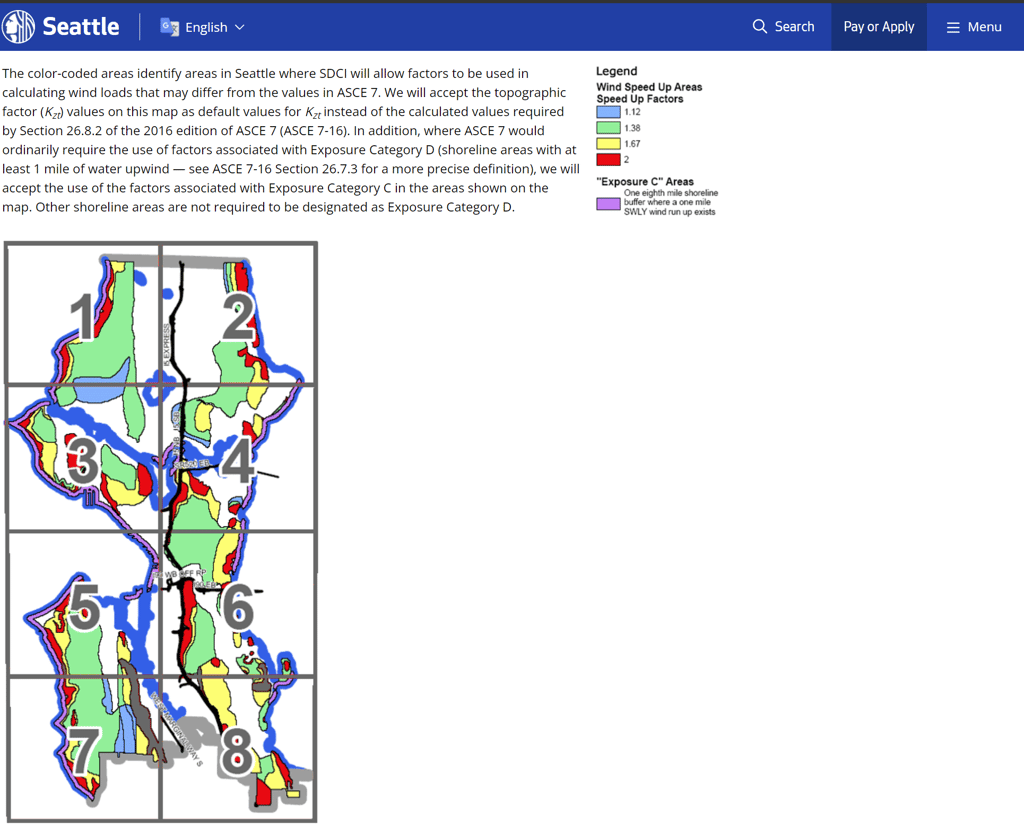
Understanding the Seattle Wind Load Factors Map:
The color-coded map is more than just a visual representation; it's an essential tool for engineers working on Seattle-based projects. Here's what you need to know:
Resource Foundation: the map is based on the wind load provisions established by the American Society of Civil Engineers in their 'Minimum Design Loads of Buildings and Other Structures (ASCE 7).'
Differing from the Standard: The distinct areas highlighted on the map indicate zones where the Seattle Department of Construction and Inspections (SDCI) permits factors for calculating wind loads that may vary from the default ASCE 7 values.
Topographic Factor Acceptance: The topographic factor (Kzt) values indicated on the map are accepted by the SDCI as standard values, superseding the calculated ones mandated by Section 26.8.2 of ASCE 7-16.
Exposure Category Deviations: In regions where ASCE 7 typically prescribes factors correlating with Exposure Category D (areas adjacent to shorelines with a minimum of 1 mile of upwind water), the map permits the use of factors associated with Exposure Category C. Notably, this doesn't mandate other shoreline zones to be categorized under Exposure Category D.
Why Trust WindCalculations.com?
As specialists in wind calculations, we're dedicated to supporting engineers, architects, and builders in their mission to erect safe, durable structures. With the Seattle-centric wind load factors map, professionals can confidently design projects that are not only compliant with local regulations but also embody the pinnacle of structural integrity.
Conclusion:
Navigating the complexities of wind load calculations in Seattle doesn't have to be daunting. WindCalculations.com can provide assistance with this process. By recognizing and incorporating accurate wind calculations load factors, Seattle's structures can continue to grace the city's skyline with beauty, safety, and resilience.
For more insights into wind engineering, continue exploring WindCalculations.com. We're here to ensure your projects achieve structural excellence in the face of nature's challenges.
WindCalculations.com
+1 (813) 694-8989
info@oasisengineering.com
© 2023 Oasis Engineering LLC. All rights reserved. Doing business as WindCalculations.com